Atlantic Ocean
Photos
47 Photos
Per Page:
Filter Categories
All
Filters
This "blue marble" image of the globe draws on data from multiple satellite missions (not all collected at the same time). The focus in this view is the North Atlantic Ocean and its surrounding land masses. Notice the thick ice pack on Greenland (top center) and the city lights on the night side of the globe. Image courtesy of NASA.

Cape Cod and Cape Cod Bay (visible at the center of the image) can be seen in this generally south-looking view. Cape Cod is a narrow peninsula, glacial in origin, that is constantly changing as winds and water move sand along the shoreline. Cape Cod extends 105 km (65 mi) east and north into the Atlantic Ocean. A portion of Martha's Vineyard may be seen in the upper right corner of the image. Photo courtesy of NASA.

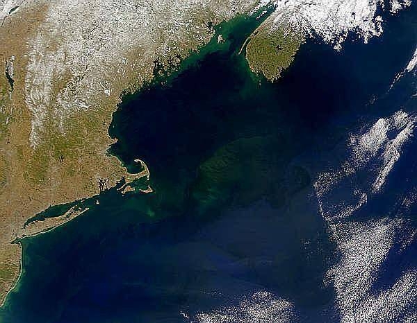
A view of Georges Bank, a large elevated area of the sea floor that separates the Gulf of Maine from the Atlantic Ocean. The Bank is situated east of Cape Cod, Massachusetts (US; on the left) and southwest of Cape Sable Island, Nova Scotia (Canada; upper right). Photo courtesy of NASA.

Satellite image of Cuba (center) and Jamaica (lower right). The southern tip of Florida, the Florida Keys, and the Florida Strait appear at the top. The bright blue green color around the islands, particularly around those of the Bahamas in the upper right, is likely due to the brighter solar reflection over the more shallow waters that surround the islands. Image courtesy of NASA.

The Isles of Scilly, an archipelago of approximately 150 islands, are located some 45 km (28 mi) southwest of the westernmost point of England (Land's End). The islands are an erosional remnant of an ancient granite intrusion, and are notable because they have been inhabited for over 4,000 years. Only five of the islands are currently inhabited. Historical and geological evidence indicates that many of the islands were larger and/or connected in the recent past. Even today, it is possible to walk between certain islands during low tides. Image courtesy of NASA.

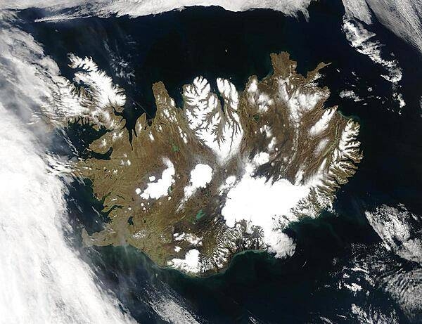
Summer temperatures melt snow and ice on much of Iceland's surface, as shown on this satellite image. The lack of uniform snow cover allows permanent (though shrinking) icefields to show through (particularly Vatnajokull in the southeast), and highlights the island's rugged coastline. Scores of fjords edge the island, resembling feathers waving out into the waters of the northern Atlantic Ocean (bottom) and Greenland Sea (upper left). Photo courtesy of NASA.

Plumes of dust blowing off the southern coast of Iceland in late June 2007. The dust appears as grayish blurs emanating from the coast southward over the North Atlantic Ocean. Blue-green algal blooms also fringe the coastline. Relatively light winter snow in 2006-07 followed by arid spring weather created the conditions for this dust storm. Photo courtesy of NASA.

This satellite photo shows the Strait of Dover in Northwest Europe. Visible are the Republic of Ireland (top leftmost), the United Kingdom (top left), France (middle left), Belgium (middle), the Netherlands (top middle), Germany (right), Denmark (top right), Luxembourg (between France, Germany, and Belgium), Switzerland (bottom middle), Italy (bottom middle), and Austria (bottom right); the latter three all cloud covered. Image courtesy of NASA.

A cloud-free natural-color mosaic of Scandinavia and the Baltic region. Image courtesy of NASA.

Red dots mark the locations of fires burning in countries south and east of the Baltic Sea in this early April image. The scattered fires were probably set to clear land for agricultural purposes. The Scandinavian countries, Norway and Sweden, and Finland to the north of the Sea, are still blanketed in snow. From the left, the countries lining the Baltic on the south are Denmark, Germany, Poland, Russia (Kaliningrad), Lithuania, Latvia, Estonia, and Russia. Belarus forms the lower right corner of the image. Photo courtesy of NASA.

Three islands of the central Azores - spear-shaped Sao Jorge Island, Pico Island with its large volcano, and circular volcanic Faial Island - are visible in this low-oblique, southwest-looking, space shuttle photograph. Image courtesy of NASA.

A space shuttle photo showing several of the northwestern islands in the Cape Verde chain in the North Atlantic Ocean, some 800 km (500 mi) from the coast of Senegal, Africa. From the upper left to lower right (northwest to southeast) one can see Santo Antao, Sao Vicente, Santa Luzia, Branco, Razo, and Sao Nicolau. Image courtesy of NASA.

Page 01 of 04