Arctic Ocean
Photos
18 Photos
Per Page:
Filter Categories
All
Filters
A global view of the Arctic on 21 September 2005, the date at which the sea ice was at its minimum extent for the year in the northern hemisphere. Image courtesy of NASA.

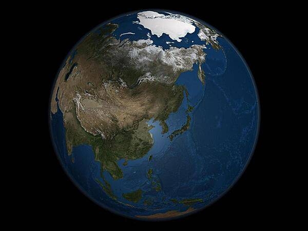
A global view of Asia on 21 September 2005, the day on which Arctic Sea ice was at its minimum extent for the year. Land areas display the average seasonal landcover from September 2004. Image courtesy of NASA.

A view of the northern part of the world showing all of glacier-topped Greenland cloud free. The point in the upper left where the longitude lines converge over the ice-clogged Arctic Ocean is the North Pole. The islands in the upper center are those of Svalbard. Image courtesy of NASA.

A magnificent satellite view of the Earth's North Pole and the entire Arctic region as seen on 22 April 2018 (Earth Day). The outline of the North American continent is visible at the bottom of the Earth's disk, while the Sahara Desert and northern Africa appear on the right-hand side. Photo courtesy of NOAA National Environmental Satellite, Data, and Information Service (NESDIS).

A polar bear pulls himself out of the ocean onto the sea ice. Photo courtesy of the US Geologic Survey/ Brian Battalie.

Adult polar bear walking across a recently overwashed barrier island during a large Arctic storm in September 2016. The barrier island is offshore of Barter Island on Alaska’s north coast. Photo courtesy of the US Geologic Survey/ Cordell Johnson.

An adult female polar bear and her two cubs travel across the sea ice of the Arctic Ocean north of the Alaska coast. Photo courtesy of the US Geologic Survey/ Mike Lockhart.

The sun can turn the Arctic ice and waters golden. Photo courtesy of the US Geologic Survey/ Patrick Kelley.

Ice on the Arctic Ocean ice cap. Photo courtesy of the US Geologic Survey/ Debbie Hutchinson.

The early morning sun bursts through clouds over the Arctic Ocean in this view taken from atop the bridge over the bow of the USCGC Healy. Photo courtesy of the US Geologic Survey/ Jonathan Wynn.

Sunset over Arctic Ocean sea ice. Photo courtesy of the US Geologic Survey/ Jessica K. Robertson.

Helicopter view of Canadian Coast Guard Ship Louis S. St. Laurent (top) and US Coast Guard Cutter Healy (bottom) on the Arctic Ocean. This rendezvous took place during a scientific expedition to map the extended continental shelf in the Arctic Ocean. Photo courtesy of the US Geologic Survey/ Jessica K. Robertson.

Page 01 of 02