Russia
Photos
36 Photos
Per Page:
Filter Categories
All
Filters
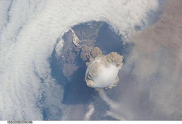
A fortuitous orbit of the International Space Station allowed the astronauts to take this striking view of Sarychev Peak volcano (Russia's Kuril Islands, northeast of Japan) in an early stage of eruption on 12 June 2009. Sarychev Peak is one of the most active volcanoes in the Kuril Island chain and is located on the northwestern end of Matua Island. Prior to 12 June, the last explosive eruption had occurred in 1989 with eruptions in 1986, 1976, 1954, and 1946 also producing lava flows.
This detailed photograph is exciting to volcanologists because it captures several phenomena that occur during the earliest stages of an explosive volcanic eruption. The main column is one of a series of plumes that rose above Matua Island on June 12. The plume appears to be a combination of brown ash and white steam. The vigorously rising plume gives the steam a bubble-like appearance; the surrounding atmosphere has been shoved up by the shock wave of the eruption. The smooth white cloud on top may be water condensation that resulted from rapid rising and cooling of the air mass above the ash column, and is probably a transient feature (the eruption plume is starting to punch through).
The structure also indicates that little or no shearing winds were present at the time to disrupt the plume. By contrast, a cloud of denser, gray ash - most probably a pyroclastic flow - appears to be hugging the ground, descending from the volcano summit. The rising eruption plume casts a shadow to the northwest of the island (bottom center).
Brown ash at a lower altitude of the atmosphere spreads out above the ground at upper right. Low-level stratus clouds approach Matua Island from the east, wrapping around the lower slopes of the volcano. Only about 1.5 km (1 mi) of the coastline of Matua Island (upper center) can be seen beneath the clouds and ash. Image courtesy of NASA.
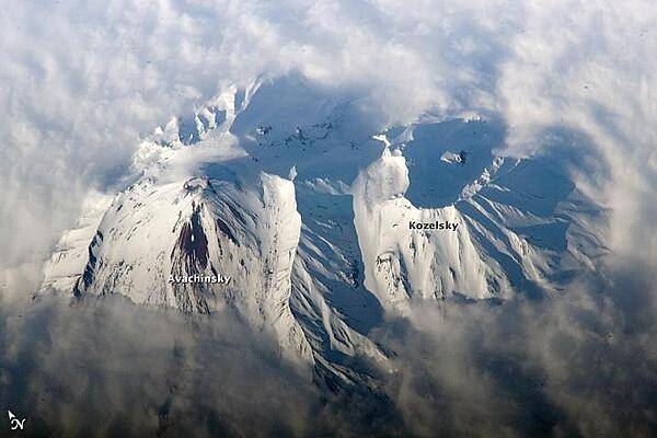
Russia's eastern Kamchatka Peninsula, which extends far into the Pacific Ocean, includes more than 150 volcanoes. While most are not actively erupting, many are considered dangerous due to their eruptive history and proximity to population centers and air travel corridors. This astronaut photo highlights the summit crater and snow-covered slopes of Avachinshy stratovolcano (2,741 m; 8,993 ft) as it pokes above a surrounding cloud deck. The volcano has an extensive historic and geological record of eruptions, the latest activity ocurring in 2008. To the southeast (image right), the large breached crater of Kozelsky volcano also appears above the clouds. Kozelsky is a parasitic cone, formed by the eruption of material from vents along the flank of Avachinsky. Photo courtesy of NASA.
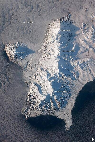
The Kuril Island chain is built from a line of volcanoes, an island arc, that extends from Russia's Kamchatka Peninsula to northern Japan. Island arcs form along an active boundary between two tectonic plates, with one being driven beneath the other (subduction). Magma generated by subduction feeds volcanoes - and eventually volcanic islands - over the subduction boundary. Paramushir Island in the northern Kurils is an example of a large island built by several volcanoes over geologic time. This astronaut photograph shows the southern end of Paramushir Island after a snowfall. The western slopes of the mountains are brightly illuminated, while the eastern slopes are in shadow.
Four major volcanic centers create this part of the island. Fuss Peak (image center left) is an isolated stratovolcano connected to the main island via an isthmus. Fuss Peak last erupted in 1854.
The southern tip of the island is occupied by the Karpinsky Group of three volcanic centers. A minor eruption of ash following an earthquake occurred on this part of the island in 1952.
The Lomonosov Group to the northeast (image center) includes four cinder cones and a lava dome.
The most recent volcanic activity on Paramushir Island occurred in 2008 at the Chikurachki cone located along the northern coastline of the island at image top center. The summit of this volcano, 1,816 m (5,958 ft) above sea level, is the highest on Paramushir Island.
Much of the Sea of Okhotsk visible in the image is covered with low clouds that often form around the islands in the Kuril chain. The clouds are generated by moisture-laden air passing over the cool sea/ocean water, and they typically wrap around the volcanic islands. Image courtesy of NASA.
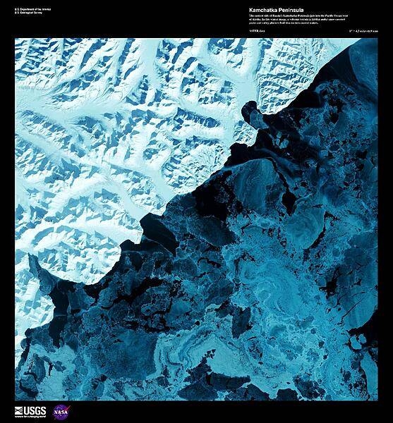
The eastern side of the Kamchatka Peninsula juts into the Pacific Ocean west of Alaska in this enhanced winter satellite image. Snow-covered peaks and valley glaciers feed blue ice into coastal waters. The Kamchatka Peninsula is home to 160 volcanoes, 29 of which are active. The Volcanoes of Kamtchaka together form a UNESCO World Heritage Site. For other active volcanoes in Russia, see the Natural hazards-volcanism subfield in the Geography section. Image courtesy of USGS.
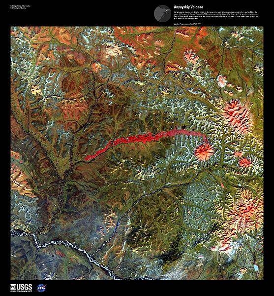
The prominent crimson streak in the center of this false-color satellite image represents the remains of a 50 km (31 mi) lahar (volcanic mudflow) that cut a strip of barren rock through rich vegetation surrounding the Anyuyskiy Volcano. The currently dormant volcano is the orange circular shape at the right end of the streak. Remote and largely inaccessible, the Kamchatka Peninsula is a rugged collection of towering volcanic peaks, steep valleys, active geysers, and wild, snow-fed rivers and streams. This volcano is part of the UNESCO World Heritage Site "Volcanoes of Kamchatka." For other active volcanoes in Russia, see the Natural hazards-volcanism subfield in the Geography section. Image courtesy of USGS.
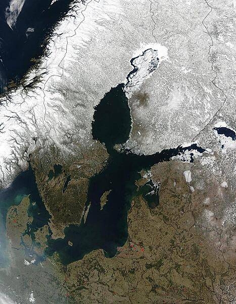
Red dots mark the locations of fires burning in countries south and east of the Baltic Sea in this early April image. The scattered fires were probably set to clear land for agricultural purposes. The Scandinavian countries, Norway and Sweden, and Finland to the north of the Sea, are still blanketed in snow. From the left, the countries lining the Baltic on the south are Denmark, Germany, Poland, Russia (Kaliningrad), Lithuania, Latvia, Estonia, and Russia. Belarus forms the lower right corner of the image. Photo courtesy of NASA.
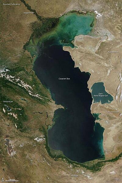
Measured by surface area, the Caspian Sea is the world's largest inland water body. It covers roughly 371,000 sq km (143,200 sq mi) and borders five countries. To the ancient Greeks and Persians, the lake's immense size suggested it was an ocean, hence its name. A large expanse of clear sky permitted this natural-color satellite image of the entire water body. The color of the Caspian Sea darkens from north to south, thanks to changes in depth and perhaps sediment and other runoff. The northern part of the lake is just 5 to 6 m (16 to 20 ft) deep. The southern end, however, plunges more than 1,000 m (3,300 ft). Just as the lake reaches a greater depth in the south, the nearby land reaches a greater height. The mountains of northern Iran line the southern end of the giant lake, and emerald green vegetation clings to those mountain slopes. In marked contrast to the mountains, sand seas line the southeastern and northern perimeters of the lake, and marshes occur along the lake shores in Azerbaijan to the west. Multiple rivers empty into the Caspian Sea, the Volga being the largest. Lacking an outlet, the Caspian Sea loses water only by evaporation, leading to the accumulation of salt. Although a lake, the Caspian is not a freshwater lake; the water delivered by the Volga River minimizes the lake's salt content at the northern end, but the Caspian grows more saline to the south. Kara-Bogaz-Gol is a saline inlet along the lake's eastern perimeter. Image courtesy of NASA.
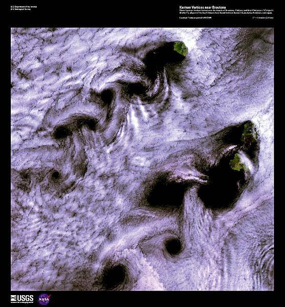
When wind-driven clouds encounter obstacles, in this case islands, they flow around them to form large, spinning eddies known as Karman vortices. The Karman vortices in this high-resolution satellite photo formed over the islands of Broutona, Chirpoy, and Brat Chirpoyev (Chirpoy's Brother), all part of the Kuril Island chain found between Russia's Kamchatka Peninsula and Japan. Image courtesy of USGS.
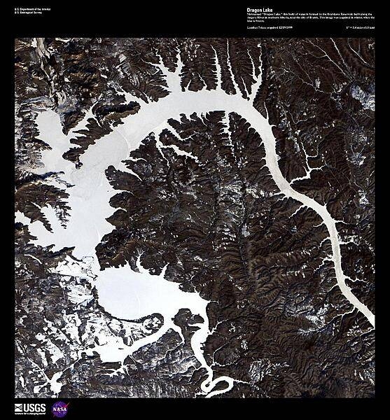
Nicknamed "Dragon Lake," this body of water is formed by the Bratskove Reservoir, built along the Angara River in southern Siberia, near the city of Bratsk. At its inauguration in 1967, the Reservoir was the largest artificial lake in the world with a surface area of 5,470 sq km (2,110 sq mi). This high-resolution satellite image was acquired in winter, when the lake was frozen. Image courtesy of USGS.
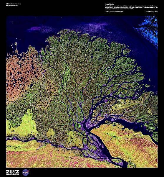
The Lena River, some 4,500 km (2,800 mi) long, is one of the longest rivers in the world. The Lena Delta Reserve, shown in this enhanced satellite photo, is the most extensive protected wilderness area in Russia; it serves as an important refuge and breeding ground for many species of Siberian wildlife. The wave-dominated delta of the Lena River is 30,000 sq km (11,580 sq mi) making it one of the largest of its kind in the world. Image courtesy of USGS.
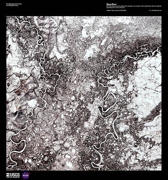
The Mayn River (on the left), seen here in a false color satellite image with a portion of the Anadyr River (on the right), flows through the far northeastern corner of Siberia. Both rivers carry a great deal of sediment and over time have created an amazing number of oxbow lakes. In this forest-tundra zone, both rivers remain frozen for 8 to 9 months out of the year. Image courtesy of USGS.
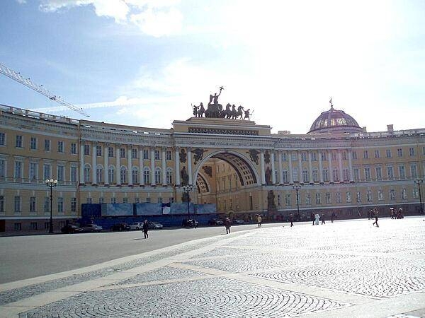
The General Staff Building in Saint Petersburg's Palace Square was built in the 1820s. The arch commemorates the victory over Napoleon; it is topped by a bronze sculpture of Victory herself riding a six-horse chariot. Under the Russian Empire, the West Wing housed the General Staff, while the East Wing contained the Foreign Ministry and the Finance Ministry. The building is now part of the Hermitage Museum.
Page 01 of 03